Cool, wet weather is helping Ontario fire crews.
The Ministry of Natural Resources Aviation, Forest Fire and Emergency Services reports no new fires in the last 24 hours.
The number of active fires has also diminished to eight, with two of those under control and one being observed.
The blaze known as Kenora #20 is among those listed as not under control and has been mapped at having burned 30,986 hectares.
Officials say crews continue to make progress with their efforts to install sprinklers on structures in Wabaseemoong.
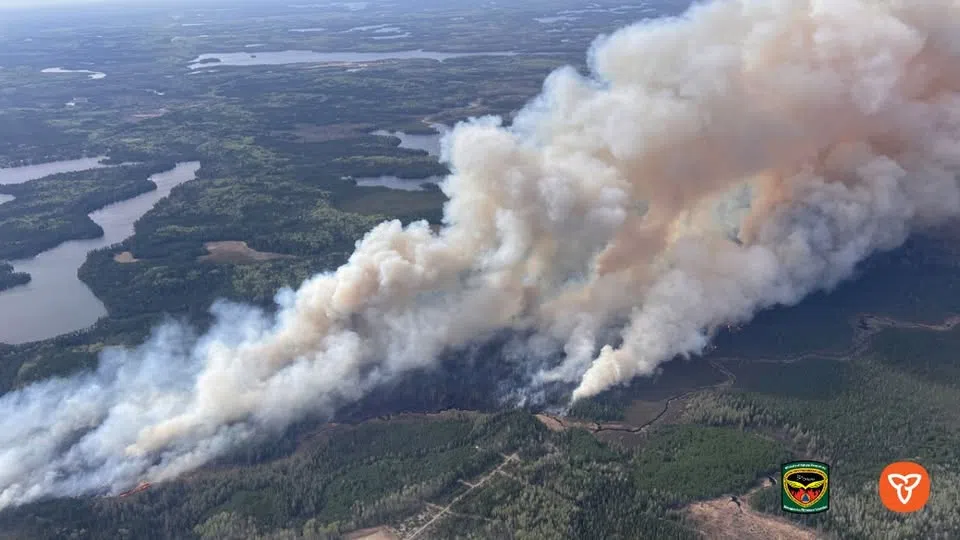
Crews are also working to protect structures at Ingolf.
Firefighters from British Columbia have arrived to assist the Ontario crews.
Twenty helicopters are also assisting in the firefighting operations.
An Implementation Order is now in effect, which prohibits travel or use of roads in and near the fire unless authorized by a travel permit.
They include Gundy Road north of Tannis Lake, Pickerel Lake Road beyond the Pelicanpouch access point at Kilometre 9, and Cygnet Lake Road.
All use of lakes and waterways within the area, including the Winnipeg River below Whitedog Falls, Eaglenest Lake, Tetu Lake, Cygnet Lake, Rice Lake, Malachi Lake, Otter Lake, Macara Lake, Longpine Lake, and Dagimabrop Lake, are also prohibited.
Kenora 14, 12 kilometres north of Wabaseemoong, is now sized at 1,617 hectares.
The Ministry says crews took advantage of its low behaviour to establish hose lines around its northeastern perimeter, and prepare helipads in anticipation of incoming crews.
The area remains subject to an Implementation Order, impacting travel on Highway 525 and the use of nearby lakes and waterways within the English River system between Tetu Lake and Umfreville Lake, and between Goshawk Lake and Umfreville Lake.
At Crystal Lake east of Atikokan, Fort Frances 4 remains at approximately 3,593 hectares in size.
Lower temperatures and minimal precipitation helped slow its spread.
The Ministry says fire suppression efforts are focused on the south end of the fire, while values protection is ongoing on the north end.
Additional personnel and aircraft are expected to be assigned to the fire over the next several days.
All travel and use of several area roads remain restricted, including Crooked Pine Road, from Sapawe Road to Camp 111 Road Junction, Bjorkman Road accessing Whiskyjack Lake off Sapawe Road Junction, and White Lily Road at the Sapawe Road Junction, while all lakes and waterways accessible from the Atikokan River system between the outflow of Crooked Pine Lake to the bridge where the Atikokan River crosses the Sapawe Road, are off limts.
Sioux Lookout 3 at Savant Lake remain at 1,849 hectares in size.
Fire crews completed values protection in the community of Saugeen and are now working with heavy equipment to tie in the north tip of the fire.
All modes of travel and use of roads, including the portion of Highway 516 East of Houghton Lake, the portion of Highway 599 North of CN rail crossing, including Savant Lake and Highway 599 South of McCubbin township, are subject to travel restrictions.
Travel on forest access roads, including 702, East Island Lake, Island Lake, and Pintail Roads, is also prohibited.
All modes of travel/access onto lakes and waterways within and including Savant, Jutten, Neston, Marchington River system, and east of and including Kashaweogama Lake are also prohibited, unless authorized by a travel permit.
A Restricted Fire Zone that went into effect on Friday for areas between Raith to the Manitoba border remains in effect.
No open-air burning, including campfires, is permitted.
Portable gas or propane stoves may be used for cooking and warmth, but use with extreme caution.
The fire hazard is predominantly low across the northwest region, with scattered pockets of moderate hazard through the western fire management sectors.